
Ely (Elyg) and the Fens
Features in: Knights of the Hawk.
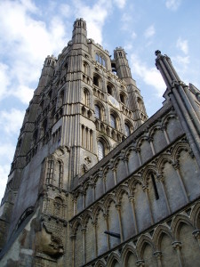
The present Ely Cathedral is largely a 12th- and 13th-century construction, built on the site of an earlier, Anglo-Saxon monastery.
One of the main centres of resistance in the years after the Norman invasion was Ely. During the Middle Ages, the monastery and small settlement that had grown up around it were surrounded on all sides by marshes and by water (see map, below), which made it an ideal base for the outlaw Hereward the Wake and his band of rebels when they rose against William the Conqueror in 1070. From this island fortress, he and his allies were able to make raids against the Normans, using their local knowledge of the landscape to evade capture.
The first religious settlement on the site was founded in c.673 by St Æthelthryth (better known as St Etheldreda or St Audrey), the wife of the Northumbrian king Ecgfrith, who became Ely’s first abbess and whose shrine later became the focus of a cult there. Not much is known about that first convent, which is widely assumed to have been destroyed when the Vikings overran East Anglia in the late ninth century. By 957, we know that the Isle of Ely had found its way into the hands of the West Saxon royal house, and in c.970 – with King Edgar’s approval – the monastery was re-founded by Æthelwold, bishop of Winchester, after which it flourished.
In 1071, King William marched against Ely, choosing to lead the army personally, which perhaps gives some indication of the significance of the threat he felt the rebels posed. However, he quickly found his progress frustrated by the marshes. Just as in Wales, where the steep forested hills presented an obstacle to cavalry, so in the Fens the combination of waterlogged ground, tangled carr (shrub woodland), and meandering, many-branched rivers negated the Normans’ one great advantage in the field: mobility. The king’s eventual solution to the problem of overcoming this difficult terrain was both ingenious and dangerous, as readers of Knights of the Hawk will know.
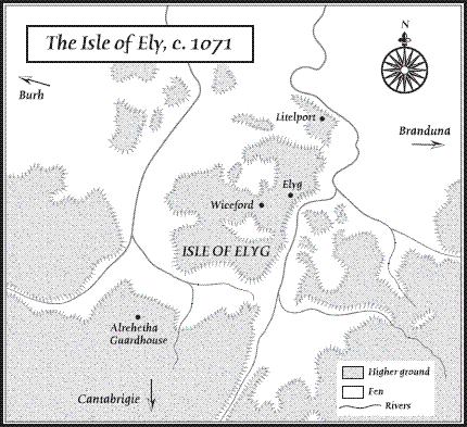
Map of the Isle of Ely, showing its context amidst the Fens. Littleport, Witchford and the Norman guardhouse at Aldreth are also marked, as well as directions to the nearby settlements of Peterborough, Cambridge and Brandon. Place-names in Old English.
Although there has never been as much development in the Fens as there has been in many of the other places featured in the Conquest Series, nevertheless much of the medieval fenland has sadly disappeared. Drainage works began in the 1630s in order to provide new land for agriculture, and continued in the eighteenth and nineteenth centuries. Nowadays, apart from the obvious flatness of the terrain, the landscape bears little resemblance to how it would have appeared in Tancred’s day.
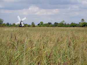
The windpump on Sedge Fen, at Wicken Fen National Nature Reserve.
However, one place where it is possible to gain a sense of what this region might have looked like at the time of the Norman Conquest is at Wicken Fen National Nature Reserve, designated a Site of Special Scientific Interest and managed by the National Trust. There the old wetlands have been preserved, providing a habitat for birds, insects and plants that are uncommon elsewhere.
At Wicken, almost uniquely, it is possible to visualise how the band of rebels led by Hereward would have been able to elude the armies of William the Conqueror. This is a fragmented landscape, with deep meres and streams dividing sedge-fields, reed banks and copses, all of which would have presented ideal hiding-places. The ground everywhere is soft, making it tricky to traverse on foot, let alone on horseback, and while safe paths through these bogs would undoubtedly have existed, the Normans would not have been familiar with them. These low-lying lands regularly flooded in winter, and closer to the sea were also subject to the daily motion of the tides.
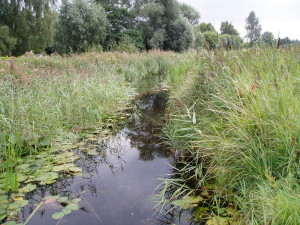
One of the many lodes that run through the Wicken Fen reserve. Dating from the post-medieval period, these acted both as drainage channels and as waterways for transporting goods, people and animals.
Exploring Wicken Fen is like visiting a lost world. What once would have comprised a substantial proportion of the ancient landscape of England is now no more than a few hundred acres in extent. Despite the absence of historical remains, the place nevertheless possesses a deep past that extends back beyond even the Normans and the Anglo-Saxons into the Bronze Age and even earlier.
If you’re interested in finding out more, the cathedral website has information about the early history of Ely. Further details about Wicken Fen, including opening times, can be found on the National Trust website.
You can also find out more about the medieval environment around Ely in this Q&A with author and artist Rus Madon, who through extensive fieldwork and archive research created his own map of the area as it would have appeared in the eleventh century.

")
")

")
")
")
")
")
")
